Carlson GeoTech 2026
Carlson Geotech 2026 – Geotechnical Software for AEC, Environmental & Construction Professionals
Carlson Geotech is a robust geotechnical and drilling software solution built for AEC firms, environmental consultants, and construction professionals who rely on accurate subsurface data for planning, compliance, and build-ready design
Designed to work directly within IntelliCAD or AutoCAD, Carlson Geotech streamlines the collection, analysis, and presentation of drilling data, soil and material classifications, borehole logs, and cross sections—eliminating duplicate drafting and preserving CAD intelligence throughout the project lifecycle
Environmental and geotechnical teams use Carlson Geotech to document soil stratigraphy, groundwater conditions, and subsurface materials for environmental site assessments, remediation planning, landfill design, and regulatory reporting. Customizable templates and standardized symbology support consistent documentation aligned with agency and project requirements
For construction and infrastructure projects, Carlson Geotech delivers clear, CAD-ready outputs to support foundation design, earthwork planning, utility coordination, and risk mitigation. Borehole logs, fence diagrams, and profiles integrate seamlessly with civil and structural drawings, improving coordination between engineers, contractors, and stakeholders
From early investigation through final construction documentation, Carlson Geotech helps teams reduce manual drafting, improve data accuracy, and produce professional deliverables faster—all within a familiar AutoCAD environment
Common Use Cases
-
Environmental site assessments & remediation projects
-
Construction and infrastructure subsurface investigations
-
Foundation, DOT & Civil roadway, and utility design support
-
Soil classification and drilling documentation
-
Regulatory and build-ready geotechnical reporting
File Format Compatibility
- Integrates with civil, survey, and structural workflows
- CAD-native files—no data translation or rework required
This module can be purchased as a standalone module or with Takeoff Suite
Important: The software module is a new, end user perpetual license. If you are an existing user, please contact us regarding renewal or cross-grade options
KEY CAPABILITIES
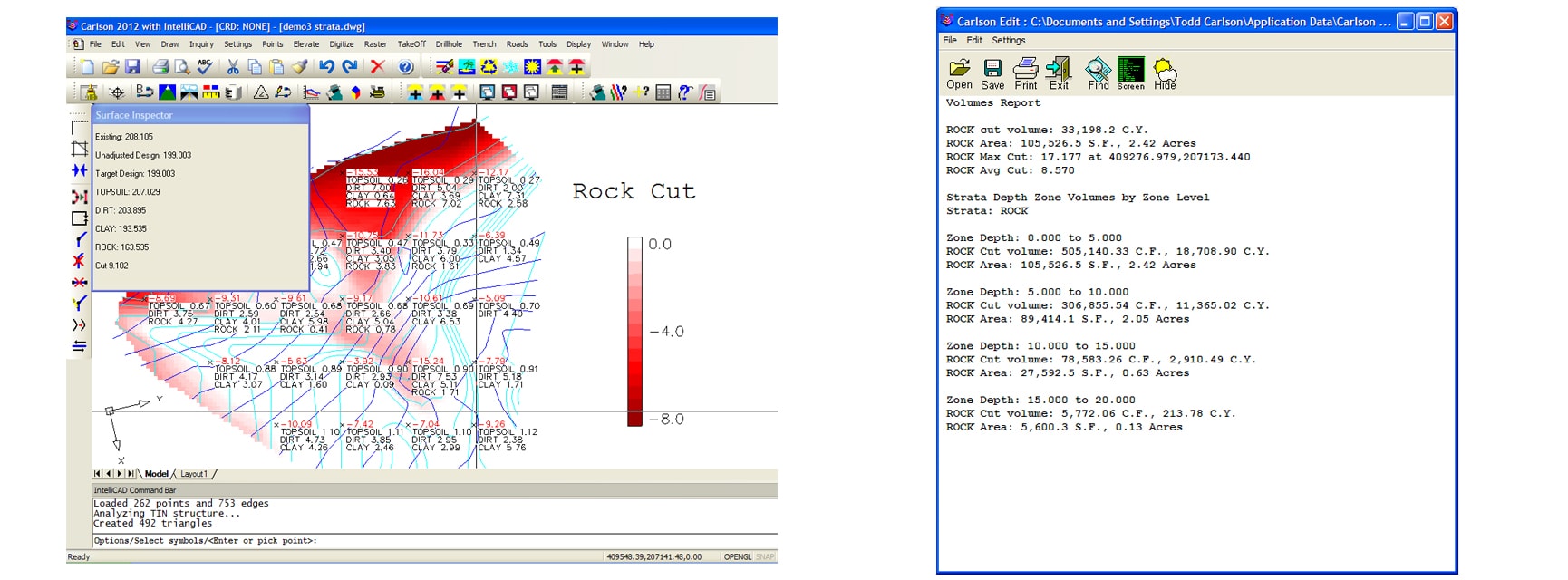
- Input and edit drillhole log data with strata elevation, depth, and attribute data
- Generate drillhole log reports
- Label drillholes
- Draw Geologic Columns
- Draw Fence Diagrams
- Draw Isopach Maps for strata thickness, elevation, or attributes
- Draw Strata Surfaces
- Draw Strata Depth Contours and Cut Color Maps
- Model Strata Surfaces with linkage to Carlson Civil and Construction for strata quantities
- Annotate plan view drillhole location maps
General
- Carlson GeoTech compatible with AutoCAD® versions 2010 to current, as well as AutoCAD® Map, Land Desktop, Civil3D, and IntelliCAD
- Input and edit drillhole log data with strata elevation, depth, and attribute data
- Fix common drafting errors
- Handy tools for working in AutoCAD® such as Join Nearest, Shrinkwrap Entities, Polyline Utilities, Drawing Inspector, Layer Inspector, and Twist Screen
- Supports LandXML and scores of specific data conversions
Surfaces
- Build Surfaces by triangulation or rectangular grids
- One step triangulate and contour from 3D entities as well as contouring from surface files
- Change surface display properties and adjust surface functions to add and remove points and breaklines and swap edges
- Earthwork volumes between triangulation or grid surfaces
- Tie cut/fill slopes from pad perimeter to surface, build pad surface, calculate and balance volumes, and edit pad parameters